Category:De Hoop, Almelo
Jump to navigation
Jump to search
| Object location | | View all coordinates using: OpenStreetMap |
|---|
windmill in Almelo, Netherlands .jpg) | |||||
| Upload media | |||||
| Instance of | |||||
|---|---|---|---|---|---|
| Location | Almelo, Overijssel, Netherlands | ||||
| Street address |
| ||||
| Located on street |
| ||||
| Has use | |||||
| Heritage designation |
| ||||
| Source of energy | |||||
 | |||||
|
This is a category about rijksmonument number 7492
|
| Address |
|
Media in category "De Hoop, Almelo"
The following 18 files are in this category, out of 18 total.
-
 2017-04-22 Molen De Hoop Almelo - Nieuwstraat between hope and….jpg 3,468 × 4,432; 8.47 MB
-
 Aanblik De Hoop.jpg 2,560 × 1,920; 1.06 MB
-

-
-

-
 Close-up van achtkante stellingmolen - AMR Molenfoto - 20541751 - RCE.jpg 1,200 × 900; 199 KB
-

-
 Elektrisch maalkoppel.jpg 1,920 × 1,080; 859 KB
-
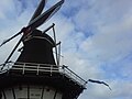
 Molen de hoop (almelo) closeup.jpg 3,072 × 2,304; 4.9 MB
-
 Molen de hoop (almelo) text closeup.jpg 856 × 252; 230 KB
-
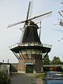
 Molen de hoop (almelo).jpg 2,304 × 3,072; 697 KB
-
Open Molendag bij molen De Hoop in Almelo.webm 1 min 26 s, 1,920 × 1,080; 50.17 MB
-
 Overzicht achtkante stellingmolen - Almelo - 20007217 - RCE.jpg 810 × 1,200; 217 KB
-
 Overzicht achtkante stellingmolen met omringende bebouwing - Almelo - 20007218 - RCE.jpg 1,200 × 1,180; 248 KB
-
Project 'nieuwe Nieuwstraat' officieel van start.webm 2 min 40 s, 1,920 × 1,080; 98.36 MB
-
Rondleiding molen De Hoop.webm 4 min 53 s, 1,920 × 1,080; 164.06 MB
-
 Straat met achtkante stellingmolen - AMR Molenfoto - 20541748 - RCE.jpg 1,200 × 900; 141 KB
-
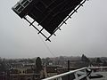 Uitzicht vanaf korenmolen De Hoop.jpg 2,560 × 1,920; 1.09 MB


_closeup.jpg)


_text_closeup.jpg)